| Via Gellia, Derbyshire |
| Matlock Bath : Twentieth Century Photographs, Postcards, Engravings & Etchings |
| |
|
|
"The Via Gellia [runs] ... along the beautiful ravine
opening out on the west of the road between Bonsall and Cromford.
... The coppice on the north side of the stream through which
the Via Gellia runs is known as Bonsall Wood ; that on
the other side is Middleton Wood"[1].
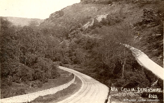
Here are six postcards of the Via Gellia. The top photograph
shows Bonsall Wood on the left and Middleton Wood on the right,
with the main road from Cromford in the valley bottom and the
road to the village of Middleton by Wirksworth climbing up the
hillside.
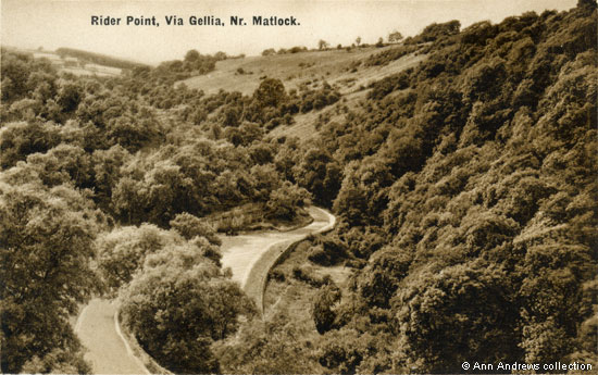
The photographs for the other cards were all taken from the
Middleton road, looking downhill towards the split, but four
way, road junction at Rider Point.
Five roads or tracks used to meet at this junction and it is
known as Five Lanes End. The main road from Cromford to Grange
Mill and Newhaven continues to follow the valley bottom, disappearing
off round the corner behind the hillside of Hopton Wood. To
the right of the curve in the road is Ible Wood. The road to
Hopton goes off to the left and the one to Middleton comes towards
the camera, passing Middleton Wood. This junction and most of
the roads were constructed very early in the nineteenth century;
only the section down to Cromford existed before then. In 1803 "The
Derby Mercury" published a notice of an application
for an Act to be put before the next session of Parliament "to
repair, widen, alter and amend the road leading from Cromford
... along the Via Gellia to Hopton ... also to set out and make
a new road, branching from the same road, up the Valley between
the Griff and Ible by Grange Mill, to or near Newhaven House
..." and another new road up to Wirksworth. The road was
to pass through several parishes i.e. Wirksworth, Matlock, Bonsall,
Brassington, Bradbourne and Hartington[2].

In 1922, following yet another motor accident, the road junction was described as
"one of the most dangerous cross-roads in the county"
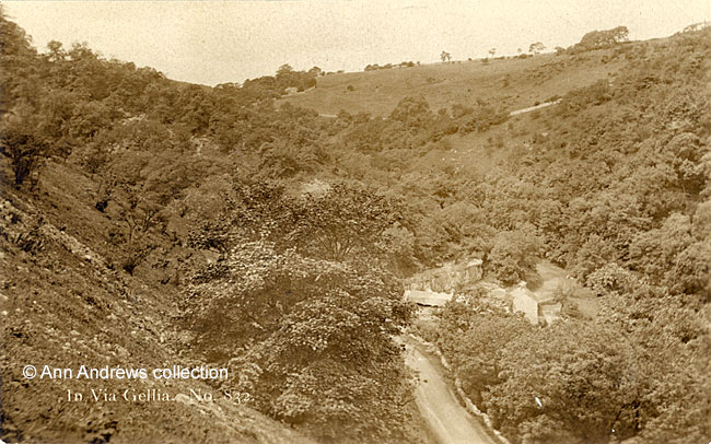
The sender of the second card had been on a works outing to
the Via Gellia from Sheffield and the group had been driven
there in large charabancs[4].
The sender had "paid into" it, so it was presumably
he belonged to a scheme whereby the workers could pay for
such trips by instalments. What looks like a rocky outcrop
on the left seems, on closer inspection, to have been a
tip or spoil heap. On Middleton Moor, not far from Rider
Point, are hillocks from old lead mines[5].
These included the Goodluck and Silvereye mines, slightly further up the hill, which were
disused by the early twentieth century[6].
Henry Moore described the Via Gellia in one of the excursions
he took from Matlock Bath in 1818. He mentioned the spoil heaps:
"The road [from Cromford] now follows the
winding of the dale, by the side of a rivulet, on which
are a succession of mills and small cascades. Rocks and
declivities with a fine mantle of foliage, and hills that
are sometimes streaked with the rubbish that is thrown
from the mines, which falls down their steep sides to the
road : these are the picturesque materials of Bonsall and
the Via Gellia[7]".
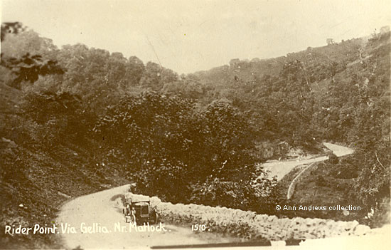
Taken shortly after the First World War.
A huge tarpaulin covers the former stables and there seems to be a protective barrier
on the top of the Rider Point rockface.
In 1925 a motorbike and sidecar unfortunately overturned whilst taking the turn at the
foot of the hill and the female sustained facial injuries. In addition to reporting the incident
a local paper commented that "the hill is very dangerous and both the warning notices
at the top are unreadable except at very close quarters. There is a twist near the top which
prevents the traveller from seeing the pitfall until he has gathered considerable speed. The
road is extremely narrow and both turns at the bottom are extremely sharp. The finger board
at Rider Point ..., which points to Hopton and Ashbourne, leads many motorists to mistake
this for the main road from Matlock to Ashbourne[8]."
In both 1922 and 1927 the County Council announced that property in the Via Gellia was to be purchased
so the dangerous Rider Point junction could be improved. However, it took some years for work
to be carried out[9].
In the 1920s and 1930s numerous cycling groups would travel downhill from either Middleton or
Hopton to Rider Point before journeying onwards, on the flat, to Grange Mill and Newhaven or to go
to Cromford. For example, in November 1925 two cyclists visited Ashbourne, Kniveton and Carsington.
After leaving Carsington they had climbed a hill between pine woods.
"To the left a deep ravine clothed with trees, and under one great beech tree
lay scattered the cloak of russet Autumn.
We asked a bucolic man in the way how far it was to Cromford, and he said, "About four
mile or it may be five or happen a bit furder". His last guess was right, and there was
no "happen" about it. So down and down we went, until we came to Rider Point in the
Via Gellia, with Cromford but two and a half miles away.
And it came to pass that when we arrived at the Greyhound it was dark, and we were a hungered.
It was a great and lovely day".[10]
The fourth and fifth pictures (above and below) were taken some years later,
probably in the 1930s, following the demolition of all the
Rider Point buildings (Ryder Point today). The road had been
widened and the trees are a little fuller. It is almost impossible
to tell where the house and its outbuildings had been.
Although it is difficult to read, the registration number of the car is believed to have been WA5038.
One journalist, writing in 1935, described the Via Gellia, from Cromford to Grange Mill, as
"four miles of fairyland". In his eyes it was the most beautiful of the "dry"
dales of Derbyshire. As he reached Rider Point, "where the roads from Middleton (Wirksworth)
- a noble aproach - and Hopton, drop steeply into the Dale" the walls closed in, "on
the left the low limestone cliffs rise straight from the roadside ... and on the other side tall trees
... making a veritable tunnel of verdure ... before the road opened out" to the Lillies inn. He
also noted that there were impressive views of the valley from the tops "notably from the
Wirksworth-Rider Point road" which are shown on these cards.
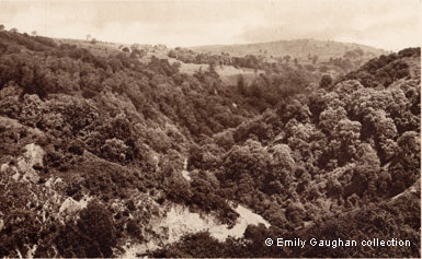
This final postcard, of the view into the valley towards Cromford from the Middleton road, was probably taken in the late 1940s.
There is another, larger version available in the "Just" images section
 |
Also see:
Davies, David Peter (1811) "History of Derbyshire" pub.
S. Mason, Belper which describes what was then the new
road through the Via Gellia and notes what was found
when it was built.
Read the transcript
elsewhere on this web site (look under Hopton) |
|
1. Top postcard "Via Gellia, Derbyshire". No publisher
details provided. No.6320. Unposted. In the collection of provided
by and © Pauline Jordan.
2. Second postcard "Rider Point, Via Gellia, Matlock Bath".
Valentine's Series No. 21586 and first published in 1894. Posted
13 Aug --- at Sheffield. Although this card has a George V stamp,
one with a very similar number was registered by Valentine & Sons
Ltd., Dundee in 1892 (this colour image replaces one from a Ward
Lock Guide, which was black and white).
3. "In Via Gellia, Matlock", C. & A. G. Lewis Limited, Nottingham. No.852. Colonial Series.
4. Fourth postcard "Rider Point, Via Gellia, Nr. Matlock".
A. W. Gessey, Bank Road and Dale Road, Matlock, Sepia Gravure Series,
British Manufacture Throughout. Not posted. Another card was posted
in 1937.
5. Fifth postcard "Rider Point, Via Gellia, Nr. Matlock".
R. Sneath, Paradise St., Sheffield - The Peak Perfection Series
No.1510. 16 Mar 193-. Personal message, not relevant to image.
Images 2-4 in the collection of, provided by © Ann Andrews.
6. Last postcard "Via Gellia", Photochrom No. 7925. © Emily Gaughan collection.
Information researched, written by and © Ann Andrews.
Intended for personal use only.
|
References:
[1] Ward Lock & Co's "Matlock, Dovedale, Bakewell
and South Derbyshire", Illustrated Guide Books of England and Wales (1926-7).
[2] "The Derby Mercury", 8 September, 1803 -
notice of application. The Act became law in 1804.
[3] "Derby Daily Telegraph", 19 June 1922.
This accident involved a motor-bike and side car - so a man, his wife and two children -
and a bicycle ridden by a local. Everyone, apart from the male motor-cyclist, required
medical treatment.
[4] See: Visitors
to Matlock Bath - Travelling by Motor Charabanc.
[5] Willis, Lynn and Parker, Harry (1999) "Images
Of England: Peak District Mining and Quarrying", pub.
Tempus Publishing Limited, Gloucester ISBN 0-7524-1710-X.
[6] The two mines were shown as still in use on the Derbyshire
map Sheet XXXIV.SW Surveyed: 1879, Published: 1884. Gell's Mine next to them was already out
of use by then. Derbyshire Sheet XXXIV.SW Revised: 1898, Published: 1900 shows all three
mines were out of use.
[7] "Picturesque Excursions From
Derby to Matlock Bath, and its Vicinity ; Being a Descriptive
Guide to the Most Interesting Scenery and Curiosities in that
Romantic District, With Observations Thereon", by Henry
Moore (1818), published by H. Moore, Drawing Master; Printed
by T. Wilkinson, Ridgefield, Manchester. This quote from Excursion
to Bonsal, Via Gellia, Middleton, Wirksworth and Cromford Moor
(from Matlock Bath) pp.102-103.
[8] "The Belper News", 7 August 1925.
[9] "Derby Daily Telegraph", 12 August 1922
and "Derby and Chesterfield Reporter", 8 July 1927 when £800 was
set aside to improve the two sharp bends at Rider Point.
[10] "Ripley and Heanor News and Ilkeston Division Free
Press", 13 November, 1925. Week By Week, by Anglo-Saxon.
[11] "Derby Daily Telegraph", 14 July
1935. Derbyshire Dales. - No. 8. Four Miles of Fairy Land. Beauty of the Via Gellia by W. H. Walton.
|
|
|