|
Images Index> Matlock Bath, 20th and 21stC Images> This page |


| Matlock Bath: Rider Point, Via Gellia |
| Matlock Bath : Twentieth Century Photographs, Postcards, Engravings & Etchings |
|
|
|||||||||||||
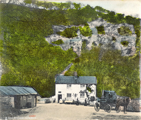
"In whatever direction we looked, the country was beautiful. The road we had passed was marked by a continued range of eminences, the outlines of which played into, and were blended with each other, in pleasing and almost endless variety"[1]. Rhodes went on to say that the "high sloping acclivities, chiefly covered with hazels, and sparingly sprinkled with dwarf oak and ash, mark each side of the road"[1]. He also mentioned that the Via Gellia was so named because of Philip Gell, the owner of Hopton Hall at that time. Here are five pretty views of the buildings at Rider Point; in 1894 this picturesque spot was described as being near the head of the Via Gellia[2]. Ible Wood covers the hillside behind the house; Griffe Grange Valley goes off to the left whilst the Via Gellia is off to the right. Several roads meet here and it was an ideal place for a toll bar in days gone by. Rider Point is at what is today the junction of Via Gellia Road (the A5012) and New Road, Middleton (the B2503) with the road to Hopton also part of the road system; the junction is known as Five Lanes End, though only four lanes are there today. The people standing outside the toll gate cottage were members of the Bainbridge family; Thomas and Emma (nee Wagstaff) Bainbridge lived in the four roomed cottage for most of their married life. They were married in Brassington on 7 Feb 1860[3]. In 1861 William Handley and his family lived at "Hipley Toll Bar"; Thomas, Emma and their young daughters Ann[4] and Esther lived in the next property. The Bainbridges were shown living at Rider Point (Ryder Point, Rider Point Gate and Via Gellia House) in all the following census returns, though their surname was sometimes, confusingly, recorded as Bembridge[5]. By 1901 Thomas "Bembridge" was described as a road maker, aged 70, but at various times before then he had also been employed as a Gamekeeper and had begun his working life as a Lead Miner[5]. Emma died in Q4 1903, aged 62, and was buried at Middleton-by-Wirksworth on 3 Dec 1903. Thomas lived for a further eight years and died on 3 September 1911, aged 81[6]. Their unmarried daughter Lily Matilda Bainbridge was living at home and acted as Thomas's housekeeper after Emma died. She married Walter H Phillips on 16 Dec 1912 at Middleton by Wirksworth. When Lily Matilda passed away in 1920 the property was referred to as Rider Point Farm[7]. Not long afterwards her husband was fined for allowing nine cows to graze along the roadside[8]. A few months later Walter moved to Water Lane, Middleton, with their four and two step children[9]. He later re-married. The largish wooden building on the left does not show up on the 1880 Ordnance Survey map, but had been built by 1899. This was possibly where the Bainbridge's served refreshments for passing visitors[10] but might have been somewhere for the horse and carriage. 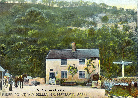
A large water butt on the right front of the property harvested water from the roof. Presumably, it was for the plants rather than drinking water. There is what looks like a trough below it, so it also may have been used for the horses. Whilst the first three cards here were posted in 1906 or 1905, they undoubtedly were taken before then, probably whilst Emma Bainbridge was alive. The first two pictures were taken a year or so apart as the small tree outside had grown slightly before the second photograph was taken. Both postcards had a side strip; the strip was designed for a very short message and the other side of the card was for the address only. The side strip disappeared from cards around 1902. 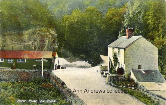 There are piles of what seems to be crushed limestone behind the outbuildings on the left of the third image, possibly in readiness for resurfacing the road. The rockface behind the stables or sheds is Rider point, at the bottom of Hopton Wood. Is it a large chicken, or perhaps a partridge, standing guard in the road? A bird is on both this image and the one above and was clearly used to both animals and people. Following the death of Thomas Bainbridge in 1911 four beasts and 20 Couple of Fowls were amongst the sale items from his estate, suggesting he sold game[11]. When a local motorcyclist crashed into a car here in 1919 there were fowls in the road[12]. The pretty cottage was demolished over a hundred years ago and the signpost has gone; all that remains to mark the spot is a collection of modern street furniture. It is difficult to know exactly when the cottage was taken down but the last date we have of pictures of the cottage at Rider Point is 1919/20[13] and the last OS map where the building is clearly drawn dates from 1922. 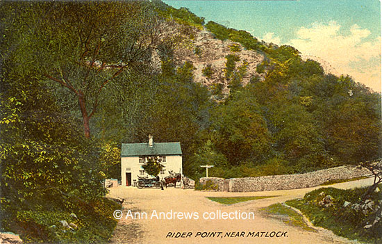 Another undated card, but the plant in the middle of the building has become quite large and was beginning to grow over the upper windows whereas the bushon the right is small. Below is a lovely water colour painting of the house by S. T. Wardle. The picture was taken to New Zealand by Audrey Constance Ward when she and her young husband Richard emigrated in 1919. Perhaps it was a memento of home, or a memory of an outing to the Via Gellia. Audrey had lived at Awsworth in Nottinghamshire where her father, Richard Place, was the headmaster of an elementary school. 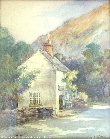 |
||||||||||||||
|
1. Top postcard: "Matlock Bath, Rider Point, Via Gellia". Published by Stengel & Co. Ltd., 39 Redcross Street, London E. C.,No.16037. Printed at Works, Dresden. Posted on 12 Aug 1907. Message not relevant to image. In the collection of and © Ann Andrews. 2. Second postcard: "Rider Point, Via Gellia, Nr. Matlock Bath". One of the Artistic Series, A. P. Co., 9 Bury Court, St. Mary Axe, London, E.C. No.1941. Chromotyped in Saxony. This image replaces an earlier version and was posted in Derby on 27 March 1905. The original image was posted 1909, but others with same view and publisher were posted 1906. 3. Third postcard "Rider Point, Via Gellia. Published by C. Colledge, Stationer, Matlock. Unnumbered. Posted 8 Aug 1906 at Matlock Bridge. 4. Fourth postcard "Rider Point, Near Matlock". E. T. W. Dennis and Sons Ltd, London and Scarborough, No.20513. Dainty Series. Printed in England. 5. Watercolour painting © Audrey Constance Ward family collection, photographed by Andrew Meyer. Information researched, written by and © Ann Andrews. Intended for personal use only. |
||||||||||||||
References (coloured hyperlinks are mainly to transcripts elsewhere on this website): [1] Rhodes, Ebenezer (1824) "Peak Scenery" pub. London, Longman, Hurst, Rees, Orme, Brown, and Green, Paternoster Row (p.312). See the map from Rhodes' book, which is another part of this web site. Via Gellia isn't shown on the map, but it was included in one of his journeys. [2] "The Derby Mercury", 28 Mar 1894. [3] Thomas' father was Samuel Bainbridge whilst Emma's father was Francis Wagstaff. [4] Thomas and Emma's eldest daughter Ann, later Ann Bridgwood of Kniveton, died at Rider Point in March 1884. She was taken ill whilst visiting her father's home ("The Sheffield & Rotherham Independent"). [5] FindMyPast has census transcripts. References for this family include: 1881, Rider Point Gate, RG11/3426 f79 p11 s21 when Thomas was a gamekeeper; 1901, Ryder Point, Hopton, RG13/3240 f74 p4 s20. [6] "The London Gazette". Thomas Bainbridge did not leave a Will, but his estate was administered by Thomas Bainbridge of Derby, a bricklayer. [7] "Belper News", 2 April 1920. Lily Matilda was 40 years old and had lived at the house all her life. [8] "Derbyshire Courier", 11 September 1920. Roadside Grazing. [9] 1921 census. [10] "Kelly's Directory of Derbyshire, 1912" (Hopton) - Refreshment Rooms, Ryder Point. [11] "Derbyshire Advertiser and Journal", 15 December 1911. Sale notice placed by his representatives to be auctioned by George Marsden & Son of Wirksworth on 20 Dec 1911. [12] "Derbyshire Courier", 2 August 1919. The motorcycle of William Crowder Johnson with his cousin George Cotterill as his passenger, collided with one of Mr. Allen's taxis whilst avoiding fowls in the road. The men on the cycle and the taxi driver were from Matlock. Both vehicles were wrecked and Cotterill's injuries were deemed to be serious. [13] With thanks to Ken Smith for checking his collection.
|