|
Images Index> Matlock Bath, 20th and 21stC Images> This page |


| Matlock Bath from the Heights of Jacob, 1908-1914 |
| Matlock Bath : Twentieth Century Photographs, Postcards, Engravings & Etchings |
|
|||
The Heights of Jacob is the area just off Upperwood Road and above what used to be the Palais Royal or Old Pavilion (now Gulliver's Kingdom); the land surrounded the old Fluor Spar Cavern. Whereas the Heights of Abraham were named after the Canadian Heights where General Wolfe was killed in 1759, the Heights of Jacob were a Victorian creation. They seem to have been the idea of a local man, Jacob Raynes, who was the proprietor of Fluor Spar Cavern. They are not recorded on early Ordnance Survey maps[1], though were mentioned in Derbyshire newspapers from 1886[2]. Visitors of the time were very complimentary about the view. For example, the unknown sender of the top card wrote glowingly of pre-war Matlock and Matlock Bath: "Grand and Glorious weather here. I am enjoying myself immensely. Climbed Jacob Heights on Wednesday & several others since. Panorama exquisite. Should like to stay a month, don't intend to hurry home." When the Darley Abbey Wesleyan choir, and several of their friends, visited Matlock Bath in 1912 "the more youthful spirits scaled the lofty Heights of Jacob, and were rewarded with a magnificent view of Matlock and the surrounding district"[3]. They visited the Fluor Spar Cavern at the same time. It is possible the climbed up the 365 steps, one for every day of the year, that go from Temple Walk (beside the entrance to Gulliver's Kingdom) up the steep hillside to close by where the Fluor Spar Cavern was. It was undoubtedly quicker than going up Holme Road and Upperwood Road but how many steps there are depends on who is counting. The panoramic view the visitors enjoyed, shown on all these pictures, looks down to North Parade and the River Derwent flowing through the steep sided valley. The tree clad slopes leading up to the Heights of Abraham rise up on the left hand hillside and the limestone outcrop of High Tor is top centre, though is slightly left of centre in the top photograph. Starkholmes straggles across the hillside on the right and John Smedley's Riber Castle has stood guard on the hilltop since 1862. Riber is clearest in the top picture, but a small part of it is also visible on the other two scenes. The large gasometer was on the far side of the railway track, near the station at the bottom of the Starkholmes hillside. It is slightly less obvious in the third image, but it is still there. The houses of Holme Road point up from the station towards the Heights, with the Round House at the Holme Road, Upperwood Road, Masson Road and Waterloo Road junction. In the Waterloo Road area the properties include Montpellier[4], Belle Vue House[5] and Wellington house can be seen. Matlock Bank and Moor is on the skyline, behind High Tor. 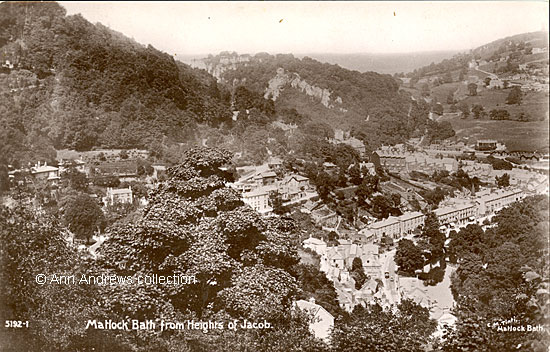
2. Before 1911, Second postcard.
What helps to date the first two images is the house called Oban on Waterloo Road (by the sharp bend of the zigzag as the road climbs the hill). In the both the first and second pictures, as well as the enlargement of image 2, Oban was just a single storey dwelling. whereas, as seen in the final image (no 4. below) in had been considerably enlarged[6].  3. Enlargement of part of image 2 above, showing the Waterloo Road properties photographed by Caletta. We can see Wellington House, Alpine Villa (then divided into two), Rokeby, thr single storey Oban (above the word "collection), Belgrano on the bend, Rose Bank/Mount (with its Gothic windows, behind Oban) and Swiss Cottage (the property below the octagonal Round House).
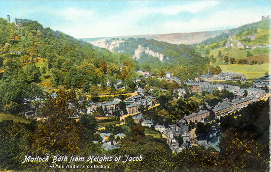 4. 1914, third postcard.
|
|||
|
1. "Matlock Bath: From Heights of Jacob", Celesque Series, published by the Photocrom Co., Ltd, London & Tunbridge Wells. No. B32691. Posted in Matlock on 2 Sept 1911 to a Miss Permain in Southampton. The picture was taken about 1908, or perhaps earlier. 2. and 3. "Matlock Bath from Heights of Jacob". The photograph was taken by Caletta M. Tinti (née Whittaker) of Matlock Bath. No. 5192-1, it was part of a series of pictures she took and published in postcard format. Card published by Davidson Bros, "Real Photographic Series", London and New York. Not posted. 4." Matlock Bath from Heights of Jacob". Valentine's Series (No.JV-79506 - but not on card). Valentine's Series is a guarantee of British Manufacture. Not posted, but the card was registered in 1914. All three postcards in the collection of, provided by and © Ann Andrews. Researched, written by and © Ann Andrews. Intended for personal use only. |
|||
|
[1] The Heights of Jacob are not shown on either the 1880 or the 1884-5 Ordnance Survey maps. They first appear on the 1899 map. [2] "The Derby Mercury", Wednesday 11 August 1886. [3] "Derby Daily Telegraph", 23 July 1912. [4] The name of Montpellier has been changed a number of times over the years. It renamed The Firs about 40 years ago, then became Hillside and has now reverted to Montpellier. It was the home of the artist Henry Hadfield Cubley for a number of years but he left the village circa 1908 - see Biographies. [5] The Donegani Family Photo lived at Belle View House at this time. [6] Also see North Parade & Waterloo Road and Heights of Abraham, Wooded Slopes. [7] "Derbyshire Advertiser and Journal", 14 November
1924. Sale Advertisement for Wellington House, home of Mr Robert Baguley: [8] Recollections of the late Mr. Frank Clay, from private papers and notes owned by Mrs. Doreen Buxton,
some of which were written in 1992 and are still within copyright. |


 There's
also a black and white, slightly larger, version of the same view
under the "Just Images" section
There's
also a black and white, slightly larger, version of the same view
under the "Just Images" section